Well, it's been far too hot in the UK this summer, so where to go to cool down?
Why, go north of course!
This'll be my second time in Arctic waters, the first exploring Svalbard a few years ago, and this time taking an expedition ship from Churchill in Manitoba, crossing the Hudson Bay to reach Baffin Island and finishing the voyage on the west coast of Greenland. Exciting stuff!
I'm travelling with long time friend and fellow adventurer Richard, last seen summiting the Mönch and more recently exceeding 70kph on his road bike...
Millions of us travel each year by plane, an event now much on a par with getting on a bus. But it's an entirely different experience travelling by sea, particularly when venturing into the polar regions. It's exciting. The vast bulk of our ship, the ice strengthened Sea Explorer, appearing on the dockside gets the adrenalin going. This is going to be our home over the next two weeks. Running the gauntlet of sudden storms, ice bergs and calving glaciers, our ship will become an old friend, protecting and nurturing us as we travel northwards beyond the Arctic Circle.
Here's our trip diary...
Day 1
 |
| Greenland, our final destination, seen from our Icelandair flight from London via Keflavik |
With my previous history of
working in the adventure travel industry I took the opportunity to meet old
friends and colleagues in Toronto - the excellent folk at Quark Expeditions,
and Dallyce Macas, owner of Eminence, a travel representation company. A great
afternoon catching up with everyone before an impressive dinner at Patria in
downtown Toronto which provided excellent Spanish tapas. A nice way to start
what will be an epic trip.
We took a private
charter flight on First Air, with the distinctive polar bear image on the tail
fin of the ageing 737 setting the scene for our journey ahead. It was 2 hour 45
minute flight to Churchill on the south west shores of Hudson Bay at the point
where the Churchill River enters the Bay.
Fortuitously, we
arrived during the calving season for Beluga Whales, and our first stop in
Churchill was a beach overlooking the Bay to view the many whales feeding here.
What looked like white-capped waves were in fact many Belugas, a sight only
seen once a year for a week or two. There's an estimated 4,000 whales in the
area right now. At this time of the year they come here to calve and the
mingling of the warmer fresh water of the Churchill River with the salt water
of the Hudson Bay facilitates the annual moult of the Beluga too.
 |
| Belugas off Churchill, Manitoba |
We then took a
short tour of Churchill, including lunch, a museum visit, and a trip to see the
local polar bear holding facility where the many polar bears that wander into
the town end up before being released at a distance from the human settlement.
Bears frequently visit the town, evidenced by one recent mauling of a local out
walking early in the morning. And it's understandable when you consider that
the local population of bears on the western fringes of Hudson Bay is estimated
at 950+ animals, somewhat greater than the permanent population of Churchill.
 |
| Welcome to Churchill! |
 |
| Boarding our home for the next two weeks, the M/V Sea Explorer |
 |
| Toughing it out in the Arctic... |
Late afternoon we
boarded our ship, the Sea Explorer, but not before a farcical customs check on
baggage, and found our luxury cabins and facilities.
But no time to
relax. We were quickly on to the Zodiacs, giving us many close sightings of the
Belugas, some blowing bubbles right next to our Zodiacs, swimming closely past
to have a look at us, some in groups of three or four, the calves grey in
colour unlike the brilliant white of their parents. This was a unique and
unforgettable experience, especially when one small pod surfaced near us,
issuing a whistling sound as they passed, justifying their popular name - 'Sea
Canaries'. What a great start to the trip!
Day 3
The ship took a
northerly track overnight on relatively calm water, a gentle swell only,
bringing us, in bright clear weather, to Marble Island, a relatively small
island with sheltered inlet used historically by whalers in the 1920 and 1930s.
It's greyish white rocks rise some 20m out of the sea, white quartzite, very
smooth in places and bearing the marks of glacial striation from the most
recent glacial period, interspersed with patterned ground and erratics of red
sandstone, greywhacke, granite and gneiss. Geologically fascinating, with
evidence from raised beaches that the island is still rising, at about one inch
per year, as it was depressed into the earth's crust under glaciation and is
now in the process of bounding back.
 |
| Colin Souness, glaciologist, on Marble Island |
Unfortunately,
the island is also littered with the graves of many whalers who perished here,
and also that of James Knight, an early explorer.
As we walked the
island, we had time to study the diverse tundra vegetation, including many
forms of lichen and moss, interspersed with patches of Arctic Cottongrass,
small flowers, dwarf trees like the tiny Northern Willow and swathes of ground
hugging berries (Arctic Blueberry, Crowberry). Easy walking, though our
expedition guide was ever watchful for polar bear, so flare gun and rifle armed
and ready just in case we were surprised.
Some bird life
seen too, some Sandhill cranes, swans, Canadian geese and various waders, plus
evidence of Arctic fox and lemming.
Late afternoon we
returned to the ship, on a one metre swell under leaden skies, a sign of the
rockier night ahead.
The day concluded
with the Captain's Cocktail Welcome before dinner.
Day 4
Overnight the
ship moved further north and then north east towards Southampton Island, the
sea rougher now with a 30 knot wind and light rain.
The deteriorating
weather forced an abandonment of our intended landing on the diminutive Walrus
Island and we proceeded eastwards towards Coats Island through the Fisher
Strait, the waves now swollen to about 3m in a Force 4-5 wind, with random
surges which ensured that we always had 'one hand for the ship'. But we made
good speed, at about 15 knots, as we were tracking the direction of the
current.
Whilst in transit
Laurie Dexter, the ship's historian, delivered a talk on human development
across the North American Arctic, followed by Bob Headland on the history of
the discovery and subsequent mapping of the Arctic regions.
Late morning
brought us to Bencus Island, just off Coats Island, and a regular haul out for
walrus. But due to shallow water we had to moor 0.5 miles off shore, and sea
conditions once again precluded any Zodiac excursions.
Our next
objective is Cape Dorset, the southwestern tip of Baffin Island. Early evening
we took shelter at Cape Pembrooke en route, but big seas ruled out any Zodiac
attempts again.
 |
| Essential rehydration on a bumpy crossing on Hudson Bay |
 |
| Greenland brew |
Day 5
It was a very
bumpy crossing overnight, entering the Hudson Strait as we slept, literally
rolled back and forth like a piece of pastry by the motion of the ship! With a
wind speed of 30 knots, grey skies and a temperature of 5 degrees C we passed another
potential landing site at Salisbury Island and continued onwards to Cape
Dorset, an Inuit community famed for its concentration of artists.
Resigned to
another three hours of transit, we were to have some more immediate excitement
though. Just as a lecture on Inuit art was concluding, a large flat-topped
iceberg appeared on the port side. Measuring approximately one square nautical
mile and estimated to contain some 324 million cubic metres of ice, this huge
piece had floated down from northern Greenland (most likely the Petermann
Glacier which had two major 'calving' events in 2012), southwards through
Baffin Bay into the Davis Strait and now residing in the Hudson Strait. This,
apparently, is a very rare sighting in the Arctic, such a large chunk of
glacier and not to be confused with the form more commonly seen in the
Antarctic (which are sections of ice shelf unique to that region). At its
furthest extent a large iceberg had detached itself from the main body, and was
beginning to tilt, its sides revealing the curved erosion of the waves that
will have battered it for months. There was also a stream of brash ice in its
wake. Now it feels like we're in a polar region!


 |
| The huge iceberg seen on route to Cape Dorset |
Cape Dorset was
to be our first 'cultural' stop, and with local guides we toured this small
settlement famed for its art industry, mainly carvings of 'dancing bears' and other fauna of the area
in local serpentine rock and soapstone, plus prints of images produced by local artists.
Locals whizz around on quad bikes, their homes brightly painted to break the
bleakness of their physical environs. They get four to five tourist ships per
year here, so there was a lot of effort made to make us very welcome, and, of
course, to buy their wares.
 |
| Local art for sale |
 |
| Heading for Mallikjuaq Island |
Later we landed
on Mallikjuaq Island, just offshore from Cape Dorset, to view the remains of
ancient Thule settlements, observe a classic inuksuk - a pile of stones used to
mark a geographic point of significance like a fording point on a river, a
navigational landmark or a stash of hunted meat - and the remains of other
settlement in the form of kayak stands and tent circles. As usual our guides
carried arms in case of polar bear.
 |
| Local Inuit guide on Mallijuaq Island |
 |
| Inuksuk on Mallijuaq Island |
As we returned to
the ship, on a much calmer sea now, the sun was starting to poke through the
clouds, a good omen for the following day. Some of the local Inuit joined us on
the ship for dinner, two of whom demonstrated the local tradition of throat
singing, a semi competitive activity, where one party sets a rhythm and tone,
the other having to match or complement it, until one falters. Clever, engaging
entertainment.
Day 6
Overnight we
headed south from Baffin Island across the Hudson Strait and moored at Digges
Island, in northwest Quebec. Once home, over a thousand years ago, to the
Dorset people, the island of gneiss rock of the Laurentian Shield (with some
black doloritic intrusions), has remnants of some thirty stone houses, a well
preserved fox/wolf trap and numerous inukchuit.
 |
| Inuksuk on Digges Island |
Digges Island,
just off the mainland, is best known for being the spot where Henry Hudson met
Inuit people for the first time, in 1610, just before his crew mutinied and
left him for dead.
From our various
viewpoints we could see lateral moraine from past glaciers, raised beaches at
different levels, and thousands of Brunning guillemots flying low over the sea on
their way to feed.
But the most
fascinating part of this landing was the Zodiac journey, on calm clear water
filled by small black pteropods (small mollusk with lateral fins, which give
the appearance of actually flying through the water) and a multitude of small
comb jellyfish, some displaying iridescent green or blue lights within their
body. Great stuff.
Then on to Eric
Cove, a Hudson Bay trading post from 1909 to 1949, mainly trading in Arctic fox
(the traders decimated by an influenza epidemic in 1928). This was our base for
a longer hike, about 10km with 400m of ascent, initially following a wide
river, with a couple of caribou seen on the far side, before heading straight
uphill to open out our views. From the top, the vastness of the landscape of
northern Quebec was revealed to us. As usual our guide, this time Christine,
scouted carefully ahead in places for polar bear, who do travel significant
distances inland during the summer months. A good yomp.
 |
| The 'chargers' above Eric Cove, northern Quebec |
Wolstanholme
Island was our last port of call for the day. The cliffs, viewed from Zodiacs,
are the hatching ground for a large colony of guillemots, home for 500,000
breeding pairs, and we were to see the spectacular fledgling behaviour, where
three weeks after hatchig, the young bird dives from its narrow perch high on
the cliff into the sea, accompanied by its father, who then take to the sea for
a few weeks before the young one is ready to take to the air. An impressive
sight, the sky around us absolutely chock full of birds going for their last feed
of the day before returning to roost.
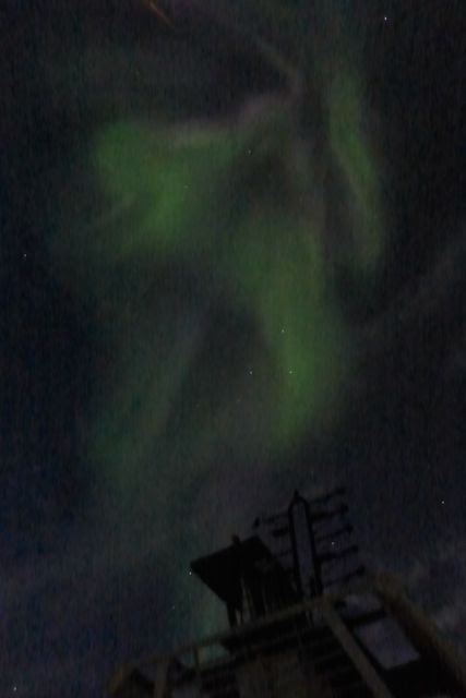
But the day had
one more surprise for us. It had been bright and sunny all day, and just after
midnight we were awoken by our expedition leader to advise that the Northern
Lights (Aurora Borealis) were displaying, so many of us donned warm clothes and
rushed to the observation deck to enjoy this wondrous spectacle. Great swathes
of light, some forming curtain like shapes directly over our heads, another
forming a spiralling trail behind the ship, and all this time the western
horizon defined by the thin red line of the last vestiges of the day.
Awesome.
 |
| No apologies for so many images of the Northern Lights...nothing quite prepares you for your first ever sighting of them! |
Day 7
A late start
given the hyperactivity of the previous day, beginning with a talk by Laurie on
the formation of the new province of Nunavut from the previously huge region of
the North Western Territories. And a good discourse of the evolution and role
of the stone pillars found throughout Inuit lands, the inuksuk. Lunch was
followed by a lecture on regional geology by Colin Souness.
Our destination
today is the small settlement of Kimmirut on the south east coast of Baffin
Island, the approach littered by icebergs. This is a small settlement of about
500 people, with no alcohol permitted to the residents, and originally a Hudson
Bay trading post called Cape Harbour. It's a bleak spot at the end of a narrow
channel expertly navigated by our Captain, not helped by the low cloud and
overwhelming greyness of the water and surrounding low hills and islands. But
lovely people here, even barbecuing Arctic Char and offering frozen raw fish
for us to enjoy. In fact it looked like the whole town turned out to greet us
as we landed on the town beach.
 |
| Kimmirut, Baffin Island |
.jpg) |
| Football match with the locals in Kimmirut |
There's not a lot
going on here, limited tourism, and mainly hunting and fishing with a small
service economy to sustain the community. Two flights a week by Twin Otter to
Iqaluit, the capital of Baffin Island, thirty minutes away. But just like
everywhere else in the world, connected via satellite and internet widely
accessible for the locals. Personally, I'm not into big group visits to
'interface' with local communities, but I was impressed with the warmth of
welcome we received, and doubly impressed with the effort that the Quark
expedition team made to have fun with the locals, talking to elders, playing a
short football match with them and giving the youngsters in the village joy
rides in the Zodiacs around our ship anchored in the harbour.
A good evening in
the bar, our little team winning the quiz :-)
 |
| Our journey across Arctic Canadian waters, now at Kimmirut |
Day 8
Overnight we
re-crossed the Hudson Strait to reach the shores of northern Quebec once more.
We were early on to the Zodiacs to land on Diana Island (Inuit: Tuvaaluk) to
view Musk-ox, part of a 2,000 head herd which was started in Nunavut (Baffin
Island) back in 1973 with the import of just three animals from Ellesmere Island.
We had some good
sightings, stealthily approaching the animals like hunters, grabbing some good
shots before the herd spooked and moved on. A few blackfly today in sunny calm
conditions on this rather boggy island, and a sighting of a couple of loons on
one of the many small lakes found here.
 |
| Musk-ox on Diana Island |
There's a few more
icebergs appearing now, and our next transit eastwards across Ungava Bay to
Akpatok Island took us through some fog banks en route.
We travelled on
Zodiacs late afternoon to the massive limestone cliffs on the western periphery
of Akpatok Island. One Polar bear had been sighted from the ship so we headed
straight for him, only to observe a mother with two cubs further along the
beach below the cliffs. She was very skittish and defensive for her offspring,
so we left them alone, spent time watching the larger bear as he scoured along
the top of a scree slope directly below the cliffs, searching for dead young
guillemots who had not survived their hallmark dive from their nests in order
to reach the sea below.
Then another two
bears were spotted northwards, one of them just beyond the cub stage who
promptly dived into the sea from the beach, either to take a closer look at us but
more likely to escape our attention. The other joined the first bear at the top
of the scree, both very watchful of each other, but their close proximity
passed without incident, both more interested in us offshore.
 |
| Polar bears on Akpatok, waiting for fledgling Guillemots to hit the beach! |
It was a fine
afternoon on the Zodiac, a bright sun warming us and giving the cliffs an
amazing hue as it started to lower in the sky.
 |
| Black Billed Guillemots ... one million birds estimated in this colony alone |
 |
| Guillemot colony at Akpatok |
 |
Off Akpatok Island in Ungava Bay |
Day 9
Overnight we
crossed the Hudson Strait once again, and moored off the Lower Savage Islands
just off southeastern Baffin Island. Our early Zodiac excursion took us through
one of two channels that divide these barren rocky islands, deep water troughs
which follow ancient fault lines. Our only wildlife sighting was a Harbour
seal, unimpressed by our approach and easy to photograph. The light on the calm
inner waters of the channel was fabulous, a silky black hue, providing
wonderful contrast to the low igneous rock bluffs on either side. But it got
very cold, and as we exited the channel to return to the ship, more bergy bits
were spotted, a sign of the colder waters we will be crossing over the next few
days.
 |
| Small bergs off the Lower Savage Islands |
 |
| Exploring the channel through the Lower Savage islands |
 |
| Harbour Seal, Lower Savage Islands |
Later we steamed
north to find the diminutive Monumental Island off the southeast coast of
Baffin Island (named as a monument to the Arctic explorer, Franklin). In
transit an excellent lecture on glaciers by Colin Souness but otherwise steady
progress in banks of fog, caused by warm air colliding with the very cold sea.
A Zodiac
operation to look for walrus on Monumental Island proved fruitless, but once
again showcased the skills of our Captain and excellent expedition team, who
navigated in choppy water with very low visibility to this tiny, rocky island
in the middle of nowhere, the latter using radar reflectors to get us back to
the ship, which appeared like a ghost ship in the spectral evening sun
attempting to cut through the fog. One polar bear was spotted by one of our Zodiac
groups.
The evening was
spent partying to celebrate our departure from the Canadian Arctic and the
start of our passage across the Davis Strait to reach the west coast of
Greenland, a journey of one day and two nights. Bizarrely the theme of the
party was Hawaiian!
 |
| Party time... |
Day 10
 |
| Neptune ceremony as we cross the Arctic Circle |
A quiet day on
the ship crossing the (thankfully) calm waters of the Davis Strait, crossing
the Arctic Circle 66 degrees N at about 1630 local time, with a ceremony led by
a colourful Neptune character and champagne and ice cream for all. Tomorrow,
Greenland!
Day 11
Our navigation of
the Davis Strait proved to be about half a day faster than expected due to very
calm conditions, although it was a largely foggy crossing, a lecture on sea ice
and glaciers keeping us occupied for part of the passage.
Our arrival in
the famous Disko Bay on Western Greenland was presaged by the sighting of many
icebergs, bergy bits and growlers (bergs of completely clear ice, containing no
air, and sitting lower in the water than the others). These are the remnants of
the many glaciers pouring off the massive Greenland Ice Cap, the second largest
in the world after Antarctica. These bergs come in all shapes and sizes, and are
a fantastic testament to the wonders of this icy wilderness.
 |
| Icebergs galore in Disko Bay |
Aided by radar to
avoid the bergs, the ship came into Disko Bay at about 4-5 knots, and calmly
took us into a narrower channel in the north-eastern reaches to start our
various excursions. Low lying fog on the landing area persuaded some of us to
take a Zodiac cruise to see some of the bergs close up, an awesome spectacle.
After dinner,
preceded by a charity auction in support of polar bear research, we observed
the nearby glacier named Eqip Sermia. With a face spanning 5km and flowing at
an astonishing 4km per year, this presented us with a unique experience, the
very frequent noises of the glacier advancing, and 'calving' into the icy waters
of the bay in which we were now anchored. The noise it made was just
incredible, regular and very loud sound akin to artillery fire or claps of
thunder - unique due to very fast flow rates of Greenland's glaciers.
 |
| Massive icebergs, Eqip Sermia, western Greenland |
Day 12
Early morning fog
closed out views of Eqip Sermia, and it's slightly less active during the
morning as the cold of the night slows the flow. It's our objective today,
walking up the lateral moraine aside this epic tumble of ice, deeply crevassed
as it has made its way to the coast. Just awesome.
An awkward
landing on to low lying cliffs, followed by a marshy walk across a rich and
colourful carpet of tundra vegetation and a few challenging river crossings
made our first landing on Greenland a memorable occasion. The walk of about 5km
there and back brought us up a short ascent on to the moraine directly next to
the magnificent glacier, the face about 200m high and frequently and noisily
calving ice into the bay below. The noise, akin to clap of thunder, was a
fabulous rendition of nature in the raw. Real goose bump stuff.
 |
| Autumnal tundra vegetation |
 |
| Fun river crossings! |
 |
| A 'calving' event from the face of the Eqip Sermia glacier |
 |
| Careful loading of the Zodiacs in a tsunami risk area |
Every time the
glacier releases ice into the bay a mini tsunami is generated, and one hit our
landing area whilst we were away walking, increasing the local high water mark
by about 8m. Accordingly, the expedition team do not land Zodiacs on to beaches
here, and use easy angled sloping cliffs to land against so that we could avoid
the tsunami effect if it occurred whilst attempting to re-board the Zodiacs on
our return. Professional, skilled stuff by the Quark team.
 |
| Disko Bay and Ilulissat, West Greenland |
Back to the ship,
Arctic dips for some from the rear Zodiac deck, and a BBQ on one of the rear
decks, the ship now repositioned to Ilulissat, Greenland's third largest town
and home for some 4,000 souls. The name of the town means 'iceberg' in Greenlandic,
and it sits next to one of the fastest moving glaciers in the world, the
Ilulisat Kangerlua or Jacobshavn Icefjord, itself 40km long and generating 20m
tonnes of ice per day. Giant icebergs, stranded on a shelf at the end of the
fjord, dominate the seascape here, huge walls, canyons, and remarkable shapes.
 |
| Fortified by vodka, the inevitable Arctic dip |
Whilst enjoying a
drink in the bar, a nearby berg calved twice right in front of the ship,
hundreds of tonnes of ice spilling into the sea and the whole iceberg titling
as the weight balance shifted. And then, a final bonus just before we turned in
for the night - a humpback whale nonchalantly swan by on our port side. We
could clearly hear the blow hole and were rewarded with a tail fluke before
this magnificent animal disappeared into the deep once again.
 |
| The cream specks show the icebergs in the channel ahead ! |
 |
| Careful navigation required on the approach to Ilulissat |
Day 13
Our penultimate
adventure day. Moored just off Ilulissat, the ship initially with a mechanical
issue that meant Zodiac transfers in the morning to reach the port. It's a
gloomy day, low cloud and fine but drenching drizzle. Many of us have
helicopter rides booked to overfly the glacier, but all that seems rather uncertain
right now.
And then things
came together. Mechanicals sorted out. Our ship docks in a very tight harbour
with much fine manoeuvring by the Captain and his crew. A good walk through the
town, the brightly coloured houses providing some respite from the gloom and
waves of drizzle that continue to ebb and flow. And then out of town, through
the kennel areas for vast numbers of husky dogs, the adults chained up for the
three or four months of the summer, the pups wandering around, seeking
attention from anybody prepared to pet them, on to a long wooden board walk
which took us into the UNESCO World Heritage Site of Ilulissat Icefjord.
 |
| Ilulissat |
 |
| Ilulissat |
 |
| Husky puppies |
|
The UNESCO World Heritage Site of Ilulissat Icefjord
And spectacular
it is, the approach taking you through vast swathes of autumnal colours on the
tundra vegetation and banks of rich green moss amidst the bog and many small
lakes. Then, very shortly afterwards you are rewarded with the spectacle of the
many icebergs caught up on the shelf at the head of the fjord waiting to be
released by the spring tides of next year, but currently blocking a 70km long
fjord and with billions of tonnes of ice waiting to move again. Massively
impressive, and visited again in the afternoon to exploit the brighter light.
 |
| Ilulissat Icefjord |
Day 14
We repositioned
southwards overnight, on fairly calm seas for the last part, the early morning
bringing us into Sisimiut, Greenland's second largest town with about 4,500
people living here, some in the attractive brightly coloured houses close to
the port but most living in drab low rise blocks further uphill out of the
town. But under bright sunshine and a chill wind, it was a good place to
wander, go visit the many husky dogs whose home was further inland away from
the town housing areas, and on our way back to the ship a chance to taste local
'delicacies' including dried minke whale meat (good), raw Beluga skin (yuk) and
some excellent local prawns, the latter being the mainstay of the local fishing
and food processing industry.
 |
| Sisimuit |
 |
| Husky dogs outside Sisimuit |
 |
| Local delicacies - dried Capelin, dried Greenland Cod, dried Minke whale, raw Beluga whale |
A transit further
south took us on big seas to the tiny village of Itilleq, on the entrance to
Hivdieqfjord, a small community focused on hunting and fishing. It was a
beautiful afternoon, albeit with severe wind chill, and the brightly painted
houses stood out amidst impressive mountain scenery inland.
 |
| The perfect spot to end our last full day in Greenland, the lovely Itelleq |
Our evening was
spent celebrating the imminent end of our journey, a gala dinner followed by
trip slideshow and, unsurprisingly, a few last beers.
 |
| The second half of our expedition, from northwestern Quebec, to Baffin Island and then across the Davis Strait to Greenland |
 |
| Final days along the west coast of Greenland |
Day 15
Day 16
Copenhagen to
Birmingham with SAS. And, back to reality!
With thanks to the Quark Expeditions team on board, capably led by Alex McNeil, and a special award for the excellent bar team led by Sixto!
 |
| Another day at the office for the expedition team! |


No comments:
Post a Comment